Proposal
for an Illawarra Regional Foreshores Park
Janice
& Robert Miller, 1 November 2001
 |
The
Case for an Illawarra Regional Foreshores Park Sandon Point Scenario |
|
| 1. Economic | ||
| Jobs ~ Tourism ~ Flood Abatement ~ Cost ~Benefit | ||
| 2. Social | ||
| Visual ~ Services ~ Crime ~ Traffic ~ Eurpoen Heritage ~ Aboriginal Sacred Site | ||
| 3. Environmental | ||
| Flora and Fauna ~ Wetland Ecology ~ Water Quality ~ Transport | ||
| 4. Legislation | ||
| 5. Conclusion | ||
<top>
PROPOSAL
FOR AN ILLAWARRA REGIONAL FORESHORES PARK
 |
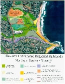
We, as residents of the Northern Illawarra, propose that a Regional Park be created along the foreshores from Thirroul to Kiama. The Illawarra currently has no regional park, and this is a situation which should be rectified by the NSW State Government. The Illawarra Foreshores Regional Parklands would be formed by a string of "pearls" linked by the existing and extended cycleway/walkway. |
|
This Regional Park has the potential to provide open space and recreation for the people of the Illawarra and south-western Sydney, as well as attracting NSW, interstate and international tourists. If fully implemented the concept would provide significant direct and indirect local employment opportunities and economic benefits.
|
Our proposal includes the extension of the cycleway/walkway to Thirroul village in the north and Kiama in the south, linking the existing community owned parks along the route. An important aspect of this proposal is the purchase by the State Government of the Sandon Point site, which is currently the subject of a development application. |
 |
|
The Sandon Point site is an Aboriginal meeting place known as Kuradji, used for thousands of years by coastal and mountain tribes, who came down the still-existing Escarpment track to the headland between two lagoons.
The Sandon Point site is crucial to the proposal, as it provides for public transport access by railway at Thirroul station, and is at the bottom of Bulli Pass for those arriving by car or bus. The site contains outstanding natural features, Aboriginal and European heritage values, and is highly visible from the Escarpment lookouts. Several cleared areas at the site might be suitable for a visitors centre, interpretive centre, carparking, and bike hire, facilities which would need to be located at the northern entrance to the regional park. The site is linked by the Throsby Track to the Illawarra Escarpment State Recreation Area.
The Sandon Point site is the last remaining coastal open space area in the northern Illawarra. It is the only remaining green link between the ocean and the Escarpment. The wetland contains extensive grasslands and wet swales which are habitat for migratory birds listed under international agreements, flora and fauna species and an ecological community listed under the NSW Threatened Species Conservation Act and the Federal Environment Protection and Biodiversity Conservation Act. The Turpentine forest at the site is listed on the Wollongong City Council heritage register.
Sandon Point - Kuradji is the site that welcomes visitors to the Illawarra.
Justification for the required expenditure of the purchase of the Sandon Point site is outlined below. This proposal provides a vision for the future of the Illawarra, rather than a short-term money making venture such as is proposed in association with the residential development of the site by Stockland Trust Group.
THE
CASE FOR AN ILLAWARRA REGIONAL FORESHORES PARK
SANDON POINT SCENARIO
<top>
1.
Economic
Jobs
The Regional Park would encourage tourism to the Illawarra, including
international visitors, interstate visitors and Sydney residents. The
location is ideal to promote to residents of western Sydney suburbs such
as Campbelltown for day and weekend excursions. The Sandon Point site,
at the northern end of the park, is readily accessible to the train station
at Thirroul, and also located at the bottom of Bulli Pass. Jobs would
be created by the increased tourist access to the Illawarra from Thirroul
to Kiama, and the provision of recreational facilities such as bike hire
shops, roller blade and skateboard hire, food kiosks, restaurants and
cultural centers. Tourism jobs are expected to be created along the entire
length of the Regional Parklands. Tourist accommodation centres would
also need to be increased in number. This proposal would provide many
long-term jobs for Illawarra residents in a sustainable manner.
The NPWS Regional Parks Policy Statement (1997) states that "There are also direct economic benefits for local communities, particularly in terms of employment".
The Stocklands Development would create a small number of jobs for builders during construction. The people who buy these dwellings would most probably have to work in Sydney due to the lack of jobs in the Illawarra. As such, economic flow-on effects from the increased population would be lessened as the residents would most likely purchase clothing, household items, etc. and services such as haircuts in Sydney where choice is greater. The development would add very few jobs to the Illawarra in the long term.
Tourism
The Regional Park would provide a focus to encourage greater tourism
to the Illawarra. The park would offer a string of open space areas along
the foreshores, linked by a cycle/walking track, and could provide services
such as car parking, bike hire, skateboarding, wetland bird viewing platforms,
picnic shelters, food kiosks, restaurants, heritage walks and information,
and an Aboriginal heritage and cultural centre. The parklands could also
offer an outdoor venue for local artists, musicians and other performers.
Within the Sandon Point area, east-west extensions of the existing bicycle
track have the potential to link other tourist facilities such as the
Illawarra Grevillea Park and the proposed Bulli Mine Museum, and onwards
along the Throsby Track to the Escarpment. The Regional Parklands would
provide a great tourist attraction, particularly for western Sydney residents.
The Stocklands Development would greatly detract from tourism within the area, as the proposed medium density housing links Thirroul with Bulli, removing the "village" and open space visual aspect of the area. This development would be highly visible from Bulli Pass and the Escarpment scenic lookouts, and would dominate the landscape along the bicycle/walking track. Why would people want to visit an area which looks just like an extension of the suburbs of Sydney? The development not only adds nothing to tourism in the region, it greatly detracts from tourism potential.
Flood
Abatement
The Regional Park would provide flood storage within the wetland
area, allowing culverts under the railway to be enlarged, thus alleviating
flooding in some existing housing areas. The wetland would be then able
to operate under more natural conditions, restoring ecological function.
The park would benefit some local residents through reduced flood levels,
thus reducing the costs of flooding.
The Stocklands Development would place housing near creeks at just above the peak maximum flood level, and would add increased runoff to the creeks. The development would do nothing to alleviate flooding in the area.
Cost
Benefit
The Regional Park would generate sustainable long-term income to
the regional economy following the initial land purchase and set-up costs.
These costs would be an investment in the future of the Illawarra from
Thirroul south to Kiama. Environmental and heritage values would be preserved
for future generations. The Regional Park would provide substantial
long-term benefits to the regional economy.
The Stocklands Development would provide some few short-term jobs and a small flow-on economic benefit to the region, however, it would reduce income to the region from tourism. Increased pressure on services such as schools, hospitals, roads and sewerage would be a cost paid by all residents. The permanent loss of environmental and heritage values is a massive cost, one which is difficult to quantify. Only Stocklands would benefit from the development. Overall, the costs to the region would be greater than the benefits.
<top>
2.
Social
Visual
The Regional Park will provide for restoration of the natural environment
along with some tourist facilities on currently degraded areas. Bulli
and Thirroul will remain as separate villages. The Regional Park open
space, wetlands and bushland, will be visually attractive from all viewing
points.
The Stocklands Development would be clearly visible from the Escarpment and Bulli Pass, as well as from Sandon Point headland and the cycle/walking track. The small block/large house medium density development does not allow space for the planting of trees in the house yards, and so the development will never improve visually. The development will remove the village aspect of the area, changing this site to more resemble a suburb of Sydney. If this development proceeds, the area will never again be visually attractive.
Services
The Regional Park would create extra load on existing services
at weekends and holiday times, with services expected to cope with demand
throughout the working week. Income generated from the Regional Park tourism
facilities could be used to amplify services as required. Service amplification
to provide for the increase in tourism would be funded by tourism income.
The Stocklands Development will require the improvement or amplification of existing services such as schools, hospitals, roadways, trains, parking at shopping centres, sewerage and water supply. These costs will be paid by all residents. Currently workday peak hour train services are not sufficient for all passengers to have a seat, and roads from Heathcote into Sydney are overloaded with workers commuting from the Illawarra to Sydney. These services would be strained by the extra load. Current services could not supply the increase in population which would result from this development.
Crime
The Regional Park would employ park rangers, design facilities
to be vandal-resistant, and increase youth-oriented facilities. Job creation
would also reduce crime levels. The increase in jobs and entertainment
facilities provided by the park could be expected to reduce crime.
The Stocklands Development proposes to provide lighting along the cycle/walking track and landscape with low plants and few trees only. The lighting would negatively impact on fauna utilising the wetlands. The landscaping plan is directly at odds with the promise to restore the endangered ecological community at the site. Crime and crime prevention appears to be a problem for the developer.
Traffic
The Regional Park would not significantly add to through traffic
using residential streets. A car park could be constructed on the site
of the old factories, with access from near the bottom of Bulli Pass.
Tourists would be encouraged to leave their car in the car park, picnic
close to the carpark, ride/walk to the beaches and other facilities, or
follow the designated tourist routes south. Any major increases in traffic
would be at weekends and holiday times, this would not place school children
at added risk. Traffic increase from tourism is manageable.
The Stocklands Development would increase the amount of traffic using local roads. Much of the traffic from the development would travel along residential streets which contain schools, in order to reach the expressway south. Traffic congestion at the lower end of Bulli Pass would be greatly exacerbated at peak periods. The development would change local streets into throughroads, increasing the risk to locals and school children.
European
Heritage
The Regional Park would enhance the old Bulli Colliery to Sandon
Point tramline / railway embankment, provide interpretive signs, and allow
a cycle/walkway from the ocean to the Escarpment. The regional park would
link many of the Illawarra's European heritage sites. European heritage
values would be preserved for future generations.
The Stocklands Development would forever destroy the old tramway / railway embankment, and prevent the use of this as a cycle/walkway link from the ocean to the escarpment. European heritage would be lost from the site forever.
Aboriginal
Sacred Site
The Regional Park would preserve and protect the Sandon Point Aboriginal
sacred site, thus providing a tangible example of the process of Reconciliation.
Tourist and recreational facilities would be developed only in close consultation
with local Aboriginal representatives. The wetlands and surrounds would
be restored to as near natural condition as possible. An Aboriginal Cultural
Heritage Centre at the site would provide an opportunity to educate the
community and overseas visitors about Aboriginal culture, and promote
understanding. Other important Aboriginal heritage sites between Bulli
and Kiama would be preserved and managed within the regional parklands.
The park would prevent a sacred site, known as Kuradji, from being destroyed,
and promote Reconciliation.
The Stocklands Development would cover a sacred site with residential housing, and build close to the sacred burial site. The development would destroy forever a sacred site, and demonstrates a complete lack of respect for indigenous cultural and religious beliefs.
<top>
3.
Environmental
Flora & Fauna
The Regional Park would restore the wetlands and surrounds as much
as is practically possible to original condition. Viewing platforms and
walkways, as well as low fences and signage, would be utilised to prevent
damage of the natural areas. The area would be managed by rangers. Other
sections of the regional parklands, such as Bellambi Lagoon, would also
be rehabilitated and managed. The park would enhance habitat, preserve
endangered ecological communities and species, and provide opportunities
for people to view and appreciate our natural heritage.
The Stocklands Development would result in the destruction of an endangered ecological community, a native grassland, a wetland, and habitat for many native invertebrates, frogs, reptiles, birds and other small mammals. The development proposes house and road construction right up to, and in some places into, the endangered ecological community. The increase in numbers of local children, dogs, and cats roaming the wetlands and ecological community would ensure the local extinction of many species, including species listed under the EPBC Act and the TSC Act. The development would forever destroy the flora and fauna of the only remaining undeveloped area which links the ocean with the escarpment.
Wetland
Ecology
The Regional Park would restore natural wetland function and ecology
along the coast between Thirroul and Kiama, and provide viewing platforms
and interpretive signs to educate the public. Natural wetland function
and ecology would be restored and preserved.
The Stocklands Development aims to channelise and re-direct creeks in the wetland from their natural regimes. Riparian and wetland vegetation would be destroyed by landscaping, trampling and stormwater management measures. Natural wetland function and ecology would be lost.
Water
Quality
The Regional Park would preserve and enhance the natural function
of the wetlands between Thirroul and Kiama, thus ensuring that waters
from the catchments are treated by aquatic vegetation. The parklands would
preserve and enhance water quality at the beaches between Thirroul and
Kiama.
The Stocklands Development would provide off-line stormwater treatment, however, the proposed design of the water quality treatment does not aim to remove more than 40% of pollutants, even during low rainfall events. Urban runoff would include pesticides, herbicides and nutrients from garden fertilisers. In conjunction with the channelisation of creeks and removal of wetland vegetation, the quality of the water entering the ocean at McCauleys Beach would be negatively impacted. The existing sewerage pumping station at the site is currently operating at peak capacity. The addition of up to 700 dwellings could be expected to result in frequent overflows from the pumping station into the creek. Water quality at the beach would be reduced as a result of the development.
Transport
The Regional Park northern end would be easily accessible by train
from Sydney. People who travel from south-western Sydney by car to the
site for recreation would do so once a week at most, and the creation
of increased tourism facilities in the Illawarra promotes holidaying closer
to home for Sydney and other New South Wales residents. The park would
not promote an increase in car travel.
The Stocklands Development would provide a dormitory suburb for Sydney. With most of the residents working in Sydney, many will drive to work and back every day. This is not sustainable development, as it would add to greenhouse emissions and consume greater energy resources. The locating of a residential suburb, without the provision of suitable employment opportunities, is not sustainable or sensible.
<top>
4.
Legislation
The NSW Government offered a clear vision and long term commitment to
the protection of urban bushland and regional open space within its Nature
Conservation Strategy. The creation of regional parks has been an initiative
of the Carr Labor Government aimed at improving the lifestyle of people
living in Sydney and regional centres, and provides an important legacy
for future generations.
The National Parks and Wildlife Service's Regional Parks Policy Statement says:
"In 1996 the Government amended the National Parks and Wildlife Act to create a new category of protected area to enable lands to be reserved as regional parks. The definition in the legislation specifies that a regional park is to include areas that have been substantially modified since European occupation and are:
- capable of providing open space and recreational opportunities for major regional population centres,
- and unsuitable for reservation or dedication as another category of land under the National Parks and Wildlife Act."
The primary focus of regional parks is to provide open space and recreation, however, the protection of conservation values is also an important management aim.
It should be noted that mining is not allowed in regional parks, and as such the Illawarra Escarpment cannot be included as a part of the regional park whilst soever coal mining continues in the area. However, it can be reserved as a State Recreation Area, to provide recreation opportunities for the more agile and fit members of the community.
<top>
5.
Conclusion
The creation of an Illawarra Foreshores Regional Parklands would be of
benefit economically, socially and environmentally to the wider community.
The parklands concept builds on the natural features of the Sandon Point
site, rather than destroying them.
Illawarra is traditionally a region with high unemployment and low socio-economic benefits. The investment by the NSW Government of land purchase and set-up costs would be an investment in the future of sustainable development in the Illawarra. The benefits would extend along the length of the park from Thirroul to Kiama, and provide a gateway to the southern Illawarra region.
The proposed Stocklands development benefits only Stocklands and their shareholders. The real costs of the development would be borne by local residents, future generations and the environment.
<top>
For
further information contact the authors of this proposal:
Janice and Robert Miller
13 Park Road
Bulli NSW 2516.
Email: z7133782@student.unsw.edu.au
Phone/fax
02 42 84 6768
www.sandon-point.org.au